Notices
| Date(s) | Description | ||||||||||||
|---|---|---|---|---|---|---|---|---|---|---|---|---|---|
| April 2026 | Havengore Bridge status: Operational and open to marine traffic in accordance with MOD byelaws. | ||||||||||||
| April 2026 | Potton Bridge status: Operational and open to marine traffic for 2 hours either side of all high tides. | ||||||||||||
| April 2026 |
Temporary monitoring installations may create an obstacle
|
A guide to navigating Maplin and Foulness Sands
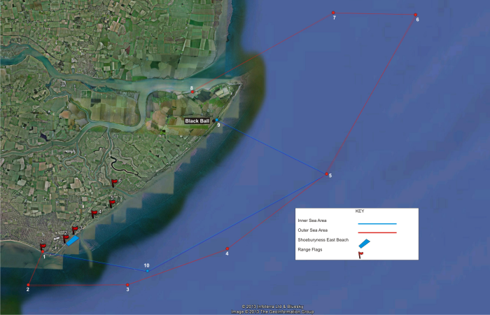
Range Sea Danger Area
The Maplin and Foulness Sands area surrounding MOD Shoeburyness is very popular for recreational sailing, watersports and fishing. If you intend to sail, board or paddle nearby you should be aware that the area outlined on the map below is a Range Sea Danger Area.
The Range operates Monday to Friday (and occasionally on weekends), all year round and is shown as being ACTIVE by the flying of Red Flags. Restrictions still apply even when the Red Flags are lowered and the Range is not active. If you are unfamiliar with navigating in the area or if you believe you have a legitimate reason to request entry to the the Range Sea Danger Area, you must contact MOD Shoeburyness as follows:
- Range Control: 01702 383211
- Marine Control: 01702 383311
- Marine VHF: Channel 72 & 16 (Call sign "Shoe Radar")
The area falls within the jurisdiction of the Shoeburyness Artillery Ranges Byelaws 1936 and the Shoeburyness and District Military Lands Byelaws 1935 (under the Military Lands Acts 1892 to 1903) which govern the rights of passage through the Inner and Outer Sea Areas that make up the Range Sea Danger Area. The byelaws exist and are applied in the interest of public safety and ensure that the Range can operate without presenting a risk.
UNAUTHORISED ENTRY INTO THE SEA DANGER AREA BY ANY TYPE OF VESSEL IS PROHIBITED AND DANGEROUS.
For more information please see our information on Flags and the Sea Danger Area.
Personal Water Craft: Public Spaces Protection Order (PWC PSPO)
In addition to the restrictions and prohibitions imposed by the MOD byelaws, the MOD foreshore is included in the 'Restricted Area' of a PSPO introduced by Southend City Council in November 2022. Fixed penalties will be issued to anyone found to be in breach of the Order. Full information can be found here.
Wakering Stairs
Stairs Road is part of the public highway and can be accessed by members of the public when the Range is not active and the red flags have been lowered. It is prohibited to launch any type of watercraft from the headway at the terminus of the road because the foreshore is part of the MOD estate, and regulated by the byelaws which state that the Inner Sea Area is closed to marine traffic at all times. Camping or over-nighting in this area (or anywhere on MOD Shoeburyness) is not permitted.